Introduction of Survey Levelling
Important Point
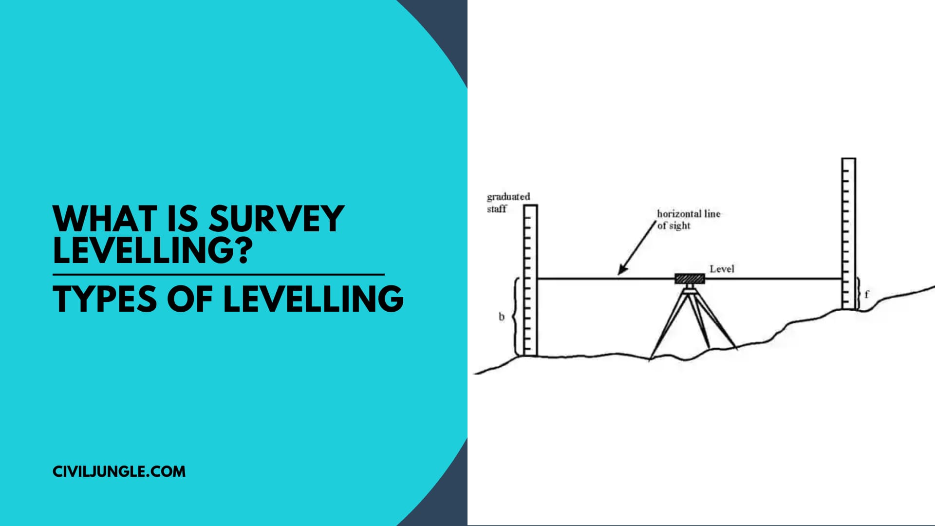
Survey leveling is the method by which we measure the elevation of one land with respect to others. It can also be defined as a method to find out the difference of elevations of different points on the earth’s surface.
It helps surveyors and engineers to level, design, plan, and construct a building by making the land suitable for construction
What Is Survey Levelling?
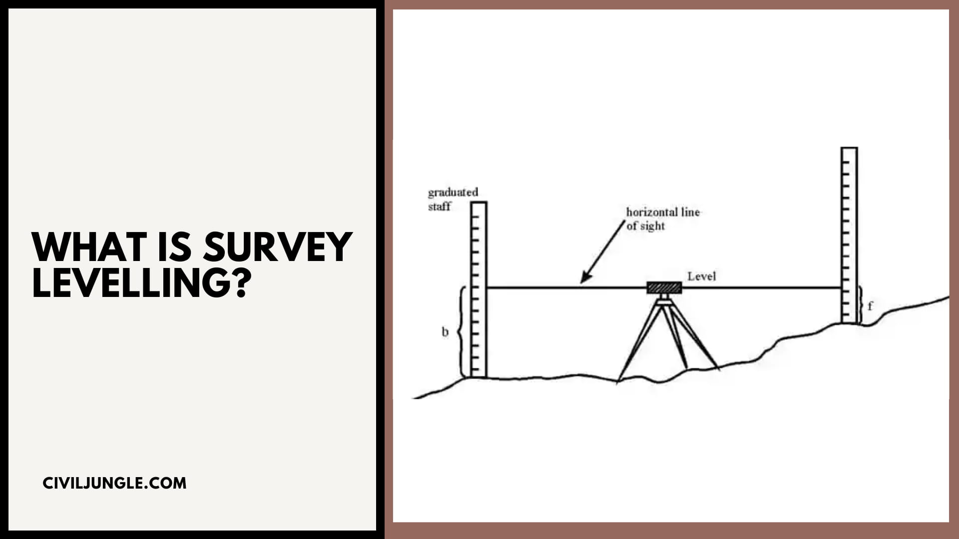
Levelling is a process of determining the height of one level relative to another. It is used in surveying to establish the elevation of a point relative to a datum or to establish a point at a given elevation relative to a datum.
Also, Read: What is Chain Surveying (Principles, Procedure, Method, Instrument)
Important Terms Related to Levelling
Elevation
- It is the vertical distance from a reference surface called a datum.
- The elevation is in positive when the considered point is above datum and negative when the considered point is below datum.
Mean Sea Level (MSL)
- It’s a datum obtained by taking the average of hourly high and low tides elevations over a long period of time of about 19 years.
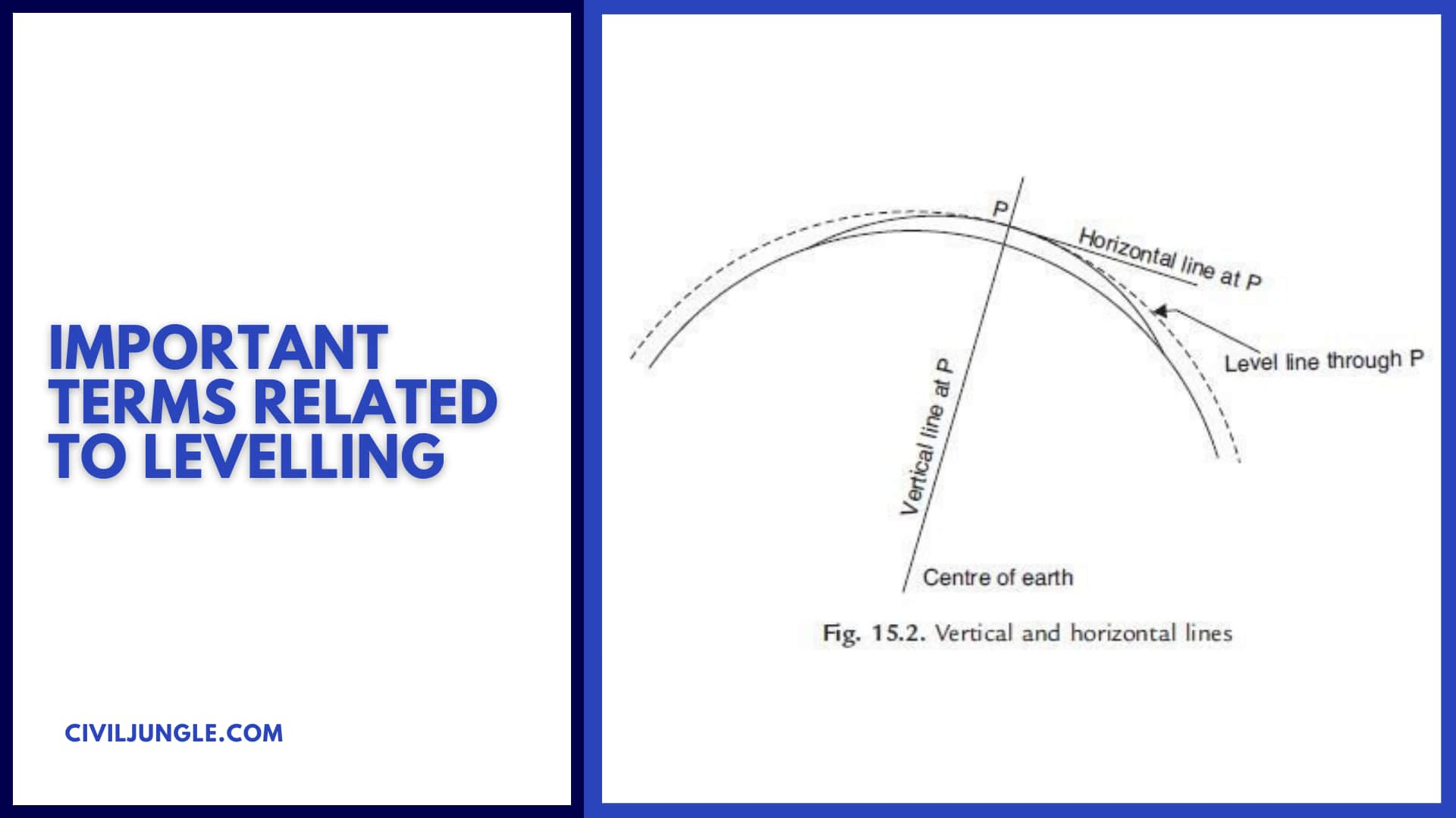
Level Surface
- A level surface is a curved surface in which all the points are at the same distance from the earth’s surface.
Level Line
- A line lying on the level surface is called a level line. It’s perpendicular to the plumb line.
Line of Sight
- It’s the line joining the optical centre of objective lens t the points of intersection of crosshairs.
Back Sight
- It’s the staff reading taken on a point of known elevation.
Foresight
- It’s the staff reading taken on a point whose elevation is yet to be determined.
- For example, if point B is to be determined, then staff reading taken on station B is called as foresight.
Intermediate Sight
- It’s the staff reading taken on the point of unknown elevation between the back sight and the foresight.
Benchmark
It’s the fixed reference point of known elevation. Benchmarks are classified into four parts:
- Great Trigonometric Benchmark
- Permanent Benchmark
- Arbitrary Benchmark
- Temporary Benchmark
Also, Read: Benchmark in Surveying | TBM in Surveying | GTS Benchmark| Permanent Benchmark| Arbitrary Benchmark
What Are Different Types of Levelling?
The different types of levelling are:
#1. Simple Levelling
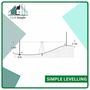
- It’s used to find out the difference between two levels which are relatively close to each other and only one setting of an instrument is enough.
#2. Reciprocal Levelling
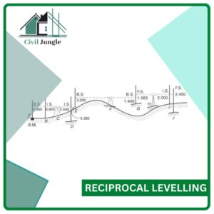
- It’s used to determine the correct difference of elevations of the two points which are too far to be measured by putting the instrument mid-way between the two points to balance the foresight and backsight.
#3. Trigonometric Levelling
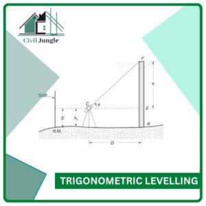
- It’s the indirect method of levelling in which the elevation of a point is determined from the vertical angle measured with a theodolite and horizontal distance measured with a tape or a chain.
Also, Read: Prismatic Compass Survey Vs Surveyor Compass. | Least Count of Prismatic Compass & Surveyor Compass
Types of Trigonometric levelling
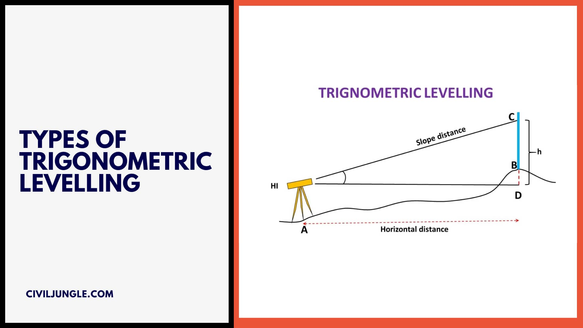
- Plain Trigonometric Levelling
- Geodetic Trigonometric Levelling
#1. Plain Trigonometric Levelling:
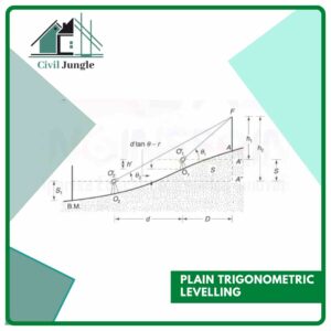
It employs the principle of plain surveying. It’s assumed that the distances measured are small compared to the radius of earth and thus the effect of earth’s curvature ad refraction can be ignored.
#2. Geodetic Trigonometric Levelling:
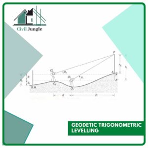
In geodetic trigonometric levelling, the distances between the points are comparable to that of earth’s radius. This is the reason that simple principles of plain surveying cannot be applied. It requires the correction due to the earth’s curvature and refraction.
- However, trigonometric levelling isn’t as accurate as direct levelling.
- With the advent of tacheometers, trigonometric levelling has now become simple because the horizontal distances also can be computed directly.
Also, Read: What Is Traversing in Surveying | Types | Method | Definition
Level Field Book
It’s the book used for entering the staff readings and reduced levels of various points. There are two methods used for the calculation of reduced levels of various points
- Height of Instrument or Height of Collimation Method
- Rise and fall method
Facts about the height of the instrument method and Rise & fall method
#1. Height of Instrument
- The first reading is always backsight.
- The last reading is always foresight.
#2. Rise and Fall method
- All the columns are same as the height of the instrument method except one- Two columns of rising and fall will replace the HI column of the height of the instrument method.
Errors in Levelling
There are many types of errors in levelling. Which is as follows.
- Instrumental Errors
- Error Due to Imperfect Adjustment
- Error Due to Sluggish Bubble
- Error Caused by Defective Staff
- Error Caused Due to Defective Tripod
- Error Caused Due to Faulty Focusing Tube
- Personnel Errors
- Error Occurs Caused Due to Careless
- Error Occurs Due to Bubble Out of Centre
- Error Occurs Due to Imperfect Focussing
- Error Occurs Due to Sighting
- Error Due to Natural Causes
- Error Due to Curvature of Earth and Refraction
- Error Occurs Due to Temperature Variation
- Error Occurs Due to Tripod Settlement
- Error Occurs Due to Sun and Wind
Also, Read: Difference Between Whole Circle Bearing and Quadrantal Bearing | What Is WCB | What Is QB
#1. Instrumental Errors
Instrument error refers to the error of a measuring instrument or the difference between the actual value and the value indicated by the instrument.
There can be errors of various types, and the overall error is the sum of the individual errors. Its types are as follows.
- Error Due to Imperfect Adjustment
- Error Due to Sluggish Bubble
- Error Caused by Defective Staff
- Error Caused Due to Defective Tripod
- Error Caused Due to Faulty Focusing Tube
#a. Error Due to Imperfect Adjustment
- If the isn’t perfect in adjustment, the resulting line of sight will be inclined when the bubble is at the centre.
- It can be eliminated by balancing the foresight and backsight.
#b. Error Due to Sluggish Bubble
- Sluggish bubble comes to rest quickly and also shift position while the sight is taken.
- This error can be avoided by making sure that the bubble is central before taking each reading.
#c. Error Caused by Defective Staff
- This error occurs due to the inaccuracy of graduations of the staff.
- If the bottom of staff has worn out then it will five wrong height of instrument but the error in foresight is balanced by the back sight and thus the calculated elevation is correct.
#d. Error Caused Due to Defective Tripod
- Unstable and weak tripod causes this error.
#e. Error Caused Due to Faulty Focusing Tube
- This error occurs due to fault in focusing tube of the external focusing telescope due to which the objective moves in an inclined direction when tuce is moved for focusing.
- It can be eliminated by taking out the defective tube and aligning it properly.
Also, Read: What Is EDM in Surveying | Types of EDM Instruments | Errors in EDM | Types of Error
#2. Personnel Errors
The errors which are introduced due to fault of the observer is known as Personal error, for example, carelessness in taking observation etc. Its types are as follows.
- Error Occurs Caused Due to Careless
- Error Occurs Due to Bubble Out of Centre
- Error Occurs Due to Imperfect Focussing
- Error Occurs Due to Sighting
#a. Error Occurs Caused Due to Careless
- Gross errors are mostly due to lack of knowledge, judgment and care on the part of an experiment.
- That is Gross error is caused by careless handling. Gross error is caused by careless handling.
- st=ettig up and levelling of the instrument
#b. Error Occurs Due to Bubble Out of Centre
- When the bubble isn’t at the centre when the sights are taken, this error occurs.
- By turning the levelling screw, we can bring the bubble at the centre and avoid this error.
#c. Error Occurs Due to Imperfect Focussing
- When the eyepiece and objective aren’t properly focused, there will be a parallax and staff readings will have errors.
- To avoid this error, we can check if the movement of the eye causes an apparent change in staff reading.
#d. Error Occurs Due to Sighting
- This error occurs when the crosshairs don’t coincide with the staff graduations.
- This error can be eliminated by keeping the distances small and taking care while sighting.
Also, Read: What Is Linear Measurement Surveying | Types of Linear Measurement Surveying
#3. Error Due to Natural Causes
The types of Error Due to Natural Causes are as follows
- Error Due to Curvature of Earth and Refraction
- Error Occurs Due to Temperature Variation
- Error Occurs Due to Tripod Settlement
- Error Occurs Due to Sun and Wind
#a. Error Due to Curvature of Earth and Refraction
- This error due to curvature and refraction is small and generally can be avoided.
#b. Error Occurs Due to Temperature Variation
- Due to the high temperature, liquid of the level tube expands and bubble gets shorten, leading to the adjustments of the instruments getting disturbed.
- This error is also small and can be neglected
#c. Error Occurs Due to Tripod Settlement
- This error occurs when the tripod isn’t set on firm ground.
- You can avoid this error by setting the tripod on firm ground.
#c. Error Occurs Due to Sun and Wind
- This error occurs when the staff reading can’t be taken properly because of any reason like bright sunshine falling on it.
- It also occurs due to high wing disturbing the tripod.
Also, Read: Instrumental Errors in Leveling | Type of Errors in Leveling
Levelling Survey
- Levelling is a process of determining the height of one level relative to another.
- It is used in surveying to establish the elevation of a point relative to a datum or to establish a point at a given elevation relative to a datum.
Permanent Benchmark
A readily identifiable, relatively permanent, recoverable benchmark that is intended to maintain its elevation without change over a long period of time with reference to an adopted datum, and is located where disturbing influences are believed to be negligible.
Arbitrary Benchmark
- Arbitrary benchmarks are assumed to be equal to 100 meters generally and then the elevations with respect to assumed benchmark are determined.
- It is commonly practised by engineering students. For GTS surveys of the country, surveyors use permanent benchmarks to calculate the elevations of different points.
Temporary Benchmark
A temporary benchmark (TBM) is a fixed point with a known elevation used for level control during construction works and surveys. Nails in road seals, or marks on kerb & channel are commonly used as temporary benchmarks.
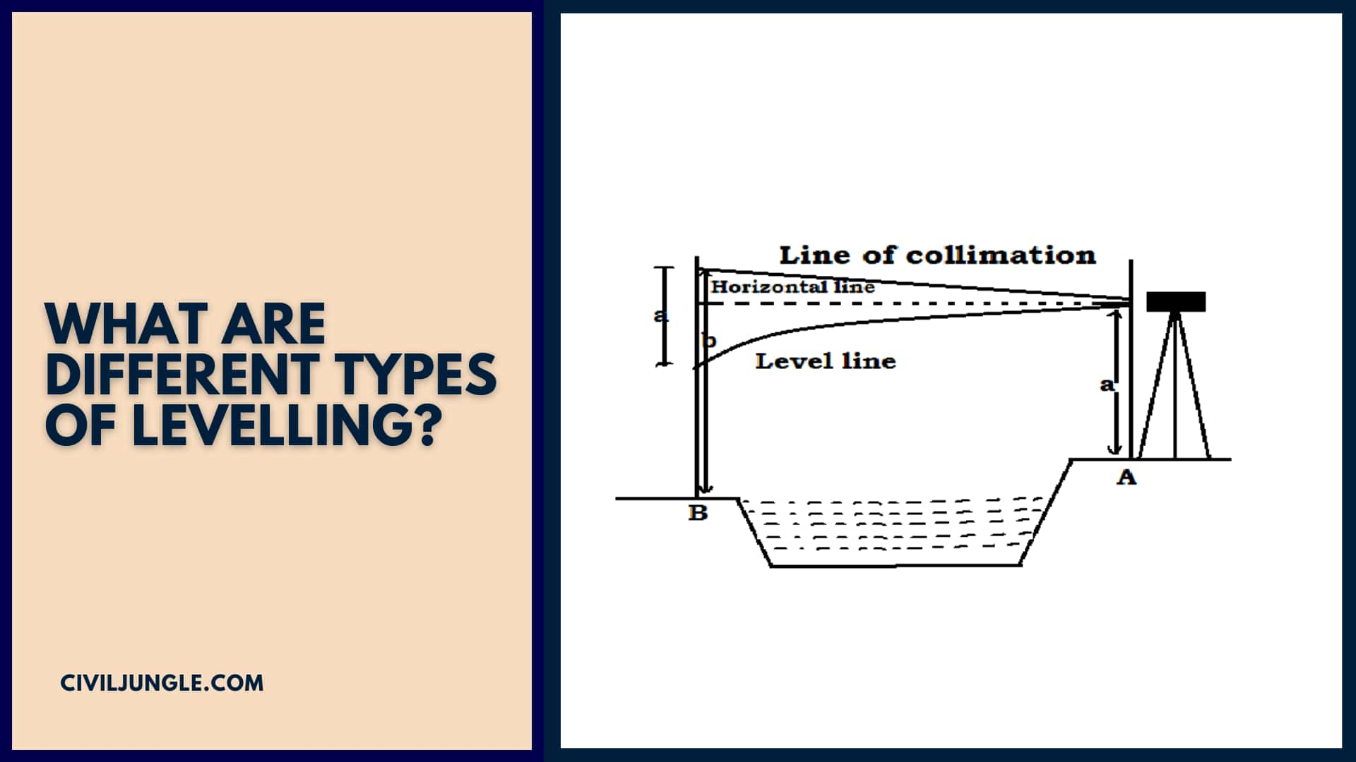
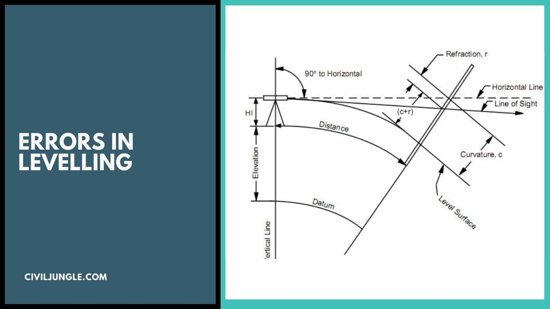
Error Due to Curvature of Earth and Refraction
Hence the error in staff reading due to curvature of the earth = 0.0785 D2 metres, where D is the distance from the level to the staff in kilometres.
The effect of curvature is to increase the staff reading i.e., this error is positive and so the correction is negative.
Error Due to Imperfect Adjustment
Explanation: Instrumental errors are due to an imperfect adjustment of an instrument, structural defects in the instrument and imperfections due to wear.
Error due to the line of collimation not being perpendicular to the horizontal axis also comes under instrumental error.
Error Occurs Caused Due to Careless
- Gross errors are mostly due to lack of knowledge, judgment and care on the part of an experiment.
- That is Gross error is caused by careless handling. Gross error is caused by careless handling.
Error Occurs Due to Imperfect Focussing
- This error is due to imperfect focusing of the eye-piece and of the object-glass.
- The parallax should be entirely elimination by proper focusing before taking any reading.
Levelling Instruments in Surveying
- Dumpy level: Often a generic term for an optical level.
- Tilting level: Replaced by the automatic level but useful where vibration is a problem.
- Automatic level: Includes an internal pendulum which allows a horizontal reading.
Laser level.
Trigonometric Levelling
Trigonometric leveling involves measuring a vertical angle from a known distance with a theodolite and computing the elevation of the point. With this method, vertical measurements can be made at the same time horizontal angles are measured for triangulation.
Intermediate Sight in Levelling
Intermediate sights – all readings taken between back sight and fore sight. These are the points whose RL is determined by the method already mentioned above in FS. Also called inter-sight readings.
Levelling in Civil Engineering
- Determining the elevation of a site for construction purposes, such as roads, buildings, and bridges.
- Creating topographic maps and contour lines for land use planning and development.
- Monitoring subsidence or settlement of structures, such as buildings or dams.
- Determining the volume of earthwork for excavation and grading projects.
- Establishing benchmarks and control points for other surveying activities.
Difference Between Surveying and Levelling
Surveying and leveling are two related but distinct techniques used in civil engineering. Surveying is the process of measuring and mapping the relative positions and distances between points on the earth’s surface. It is used to create maps and plans for land development, construction projects, and other applications. Surveying can involve a range of techniques, including angle measurement, distance measurement, and coordinate measurement using tools such as theodolites, total stations, and GPS receivers. Levelling, on the other hand, is a specific technique used in surveying to determine the relative elevation or height of points on the earth’s surface. It is a technique that is used to create contours and cross-sections of the land, and is essential for projects such as road construction, building construction, and dam construction.
Process of Levelling
- Establishing a reference point: The first step in leveling is to establish a reference point with a known elevation, such as a benchmark or a control point. This reference point serves as a starting point for all subsequent measurements.
- Setting up the leveling instrument: Once the reference point is established, the leveling instrument is set up over it. The instrument is usually mounted on a tripod and leveled using its built-in spirit level.
- Measuring the height of the leveling rod: The surveyor then takes a measurement of the height of the leveling rod held vertically at the point being surveyed. The leveling rod is a graduated staff, typically made of wood or aluminum, with marks indicating the height above the ground.
- Calculating the elevation difference: The difference in elevation between the reference point and the surveyed point is then calculated using the height of the leveling rod, the distance from the instrument to the rod, and the height of the instrument.
- Repeating the process: The process of measuring and calculating the elevation difference is repeated for all points of interest, creating a series of height measurements.
- Plotting the results: The results of the leveling measurements are then plotted on a topographic map or used to create contour lines, which represent the height of the terrain at different locations.
Auto Level Survey
An auto level survey is a type of surveying method that uses an automatic level instrument to determine the relative elevation of points on the earth’s surface. Auto level surveying is widely used in civil engineering and construction projects to determine the height of different points on a site, create topographic maps, and establish elevation benchmarks.
Explain the Term Levelling
Levelling is a surveying technique used to determine the relative height or elevation of points on the earth’s surface. The purpose of levelling is to create a detailed and accurate representation of the topography of a given area, which is essential for a range of engineering and construction applications.
What Is Closed Linked Levelling?
Closed loop levelling, also known as differential levelling, is a technique used in surveying to determine the difference in elevation between two or more points on the earth’s surface. In closed loop levelling, the survey is conducted by starting and ending at the same point, creating a “closed loop” of measurements.
Leveling Up Survey
Levelling up survey, also known as differential levelling or trigonometric levelling, is a surveying technique used to determine the difference in elevation between two points that are separated by a long distance, such as across a valley or a river. It involves measuring the angle of elevation between the two points and using trigonometry to calculate the difference in elevation.
Leveling in Construction
Levelling is a critical part of the construction process, as it ensures that the foundation, walls, and other elements of the building are constructed on a level surface. Levelling helps to ensure that the building will be stable and structurally sound, which is essential for the safety and longevity of the structure.
Levelling Work
Levelling work is a process of determining and establishing the relative heights of different points on the ground, creating a level surface for construction, engineering, or other applications. It involves using surveying tools and techniques to measure the height of different points on the ground and create a detailed topographic map of the area.
What Is Block Levelling in Surveying?
Block levelling is a surveying technique used to determine the elevation of a large, flat area such as a building site, airport runway, or bridge deck. The method involves dividing the area into a grid of smaller sections, or “blocks,” and then levelling each block individually to create a level surface.
Like this post? Share it with your friends!
Suggested Read –
- Top 10 Tiles Companies in India 2020
- What Is Plaster | Requirement of Good Plaster | Types of Plasters
- What Is Beam Bridge | Types of Beam Bridges | Beam Bridge Works | Advantages & Disadvantages of Beam Bridges
- What Is Hydraulic Cement | Hydraulic Cement Uses | How to Apply Hydraulic Cement | Advantages & Disadvantages of Hydraulic Cement
- What Is Rock Cycle | Types of Rocks | Processes in the Rock Cycle | What Are the Steps of the Rock Cycle | Uses of Rocks in the Construction
- What is Waffle Slab| Waffle Slab Details | Advantages & Disadvantages Waffle Slab | Waffle Slab Design | Construction of Waffle Slab

Sir I want to download this topic as pdf