What Is Surveying?
From ancient times, land surveys were conducted to determine the extent of land and to determine the area of land and to determine the area.
Engineering projects such as dams, canals, roads, railways, water supply pipelines, sewage, wastewater, buildings, bridges, etc. have to be planned and constructed before construction.
This requires topography of the soil surface and other information. This information is obtained through surveys.
Example: If a dam is to be built, how much area will be submerged by the dam, how many villages will have to be relocated, how much water will be collected in the lake, etc. Information is made by planning a survey of that area.
Also, read: First Angle Projection & Third Angle Projection Symbol (Orthographic Projection)
Principles of Surveying:
Various actions and methods are used in the survey to measure the area.
These actions and practices are based on some simple and simple principles. These principles are derived from the experiences of the great surveyors.
Keeping them in mind while surveying can help eliminate errors. And accuracy can be maintained in surveys.
The main principles of the survey are as follows
- To Work from the Whole to the Part .
- To Fix the Position of a New Station by at Least Two Independent Processes .
- To Choose the Method of a Survey That Is the Most Suitable for the Purpose.
- To Record Filed Data Carefully .
Also, read: Dynamic Vs Kinematic Viscosity (Difference & Definition)
Measurements of Distance by Chain Surveying:
Chains and scales are commonly used to directly measure the linear distance between two points above the earth’s surface.
We will study the types of these chains and measurements and how the distances are measured by the primary purpose of the survey is to create maps.
The maps are drawn in a horizontal plane. Therefore the distance should also be measured in a horizontal plane.
That is, if the surface is sloping, its equilibrium distance is found to be horizontally spaced and only then is it used to draw a map.
The distance between two points in the survey is the horizontal distance between them.
Also, read: Procedure for Rcc Concrete
Instruments Used in Chain Surveying (Survey Instruments)
What Instruments are Used in Chain Surveying? As follows.
- Chain or Tape.
- Arrows (Arrows in Surveying).
- Pegs.
- Offset Rods.
- Range Rod (Ranging Rod).
- Offset Rods.
- Hammer.
#1. Chain or Tape-
Before the metric system was implemented in India, a 100-foot engineering chain, a 66-foot gutter chain, and a 33-foot revenue chain were used.
Now metric chains of 5, 10, 20 and 30-meter lengths are used. The survey uses more of the 20 and 30-meter chains. The chains are 4 mm wide. They are made of a small link of galvanized wire of diameter.
Each link is made into a circular loop by bending it and then connecting the links with rings to make the whole chain so that the chain is flexible.
Usually, three rings are placed between the two links. The two rings are elliptical and the middle ring round.
A handle is pulled to both ends of the chain, and the handle is attached to the chain with a sliding joint so that it can rotate around the ends of the chain.
The chain length is inscribed on the handle of the chain.
The length of the link of each metric chain is 20 cm. To have that is the 5-meter chain is made up of 25, 10-meter chain 50, 20-meter chain 100, and 30-meter chain 150 links. IS 1492-1970 details metric chains.
In each 5 meter chain, a meter of brass tile is attached at the end of each meter. It has 1 tooth and 4-meter tally to one teeth, while 2 meters and 3-meter tally have two teeth.
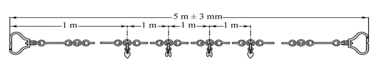
Measurement Chain 5 m Long
Even in a 10-meter chain, a meter of brass is attached at the end of each meter. It includes 1 to 9-meter tally to one teeth, two and 8-meter tally to two teeth, 3 and 7-meter tally to three teeth, 4 and 6-meter tally to four teeth and about 5 meters in front the tally is circular.
In this way, the telephoto can be used to swim at any end of the chain.
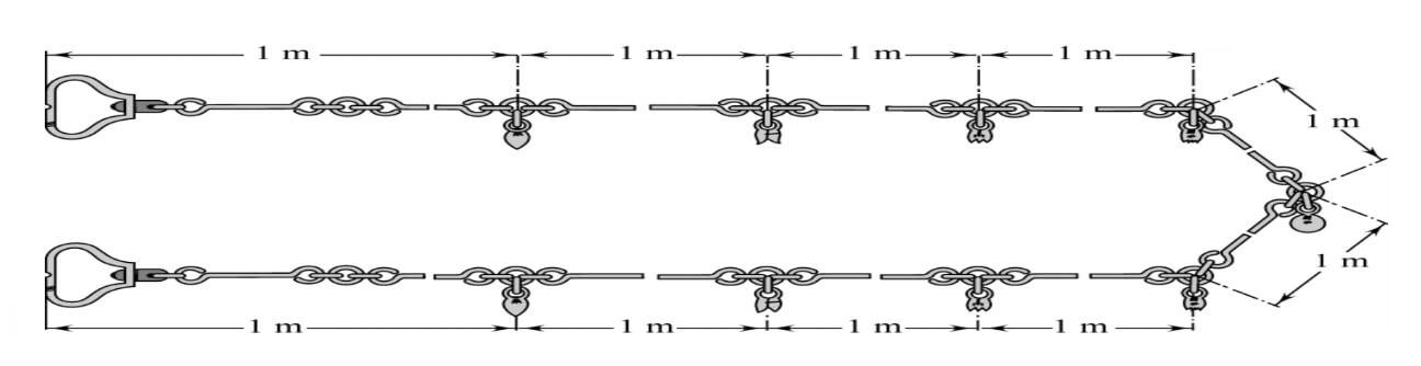
Measurement Chain 10 m Long
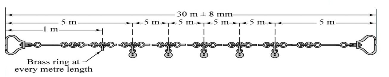
20 and 30-meter chains have a brass ring at each meter distance and a brass ring at every 5 meters instead of a brass ring. M (Meter) is engraved on each of these tiles so that it can be realized a metric chain.
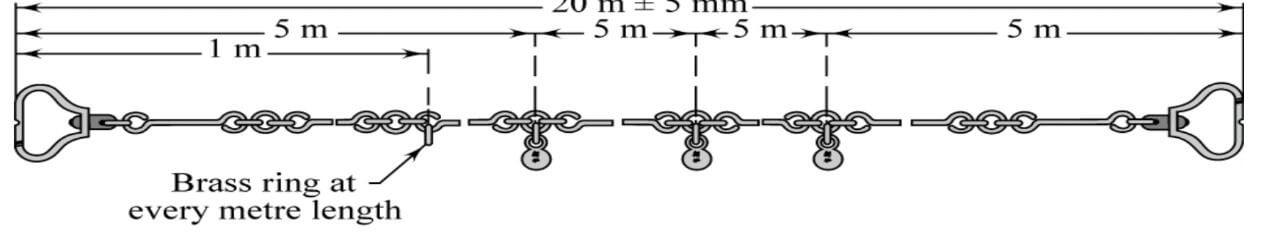
Measurement Chain 20 m Long
Both handles of the chain have a small hemispherical groove on the outside. When measuring the distance, the arrow has to be dug in the ground, keeping it exactly in the groove.
Similarly, when making the next measurement, the knob arrow has to hold the chain handle exactly as it is in this groove.
Doing so does not make the error in the measurement of the length equal to the thickness of the arrow.
Measurement Chain 30 m Long
#2. Arrows (Arrows in Surveying)-
When measuring the length, a chain is given 10 arrows along a chain when measuring the distance to mark the end of the chain properly and to calculate the entire chain-lengths.
The arrow is 4 mm. A good quality of diameter is made of soft steel wire. The lower end is curved, while the upper end is rounded with a 5 c.m. loop.
It is dressed in black enamel. IS 1842-1901 Its length is 40 cm.
![]()
Arrow as per IS 1842-1901/(Arrows in surveying)
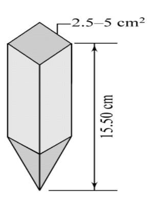
#3. Pegs–
Wooden plots are used to indicate the position of the survey points or the final points of the survey line on the ground. They are made of solid wood.
Its head is square and is sharpened, leaving the lower end in torture. Their headings are 2.5 cm x 2.5 cm or 3 cm x 3 cm, and their length is 15 cm. But for shallow soil 4 cm x 4 cm
40 cm with an intersection of Longer noses is more convenient.
They are stacked on the ground with a wooden hammer in such a way that their head is 4 cm above the ground surface. Stay high Nails are mounted to indicate the precise location of the survey station.
Pegs
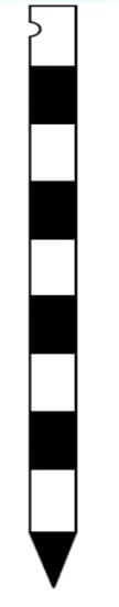
#4. Range Rod (Ranging Rod)-
One has to draw in a straight line to measure. Drawing penalties are used for drawing.
The fine is 2 or 3 meters long, as shown below. Its diameter is usually 3 cm as much as Sometimes it is also octagonal in the intersection. It is made of wood or bamboo.
It has to be 15 cm in one end to allow it to be placed in the ground. A long iron cone-shaped shoe is worn.
It should be white and black or white and red or white, red and black, 20 cm in order to make the fine appear from a distance. It is painted in strips of length. When the distance between the survey locations is greater, red, white, or yellow color is placed on the upper end of the drawing bar. (Ranging rod)
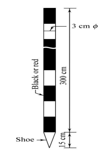
Ranging Roads (Ranging rod)
#5. Offset Rods-
An offset fine is used to rotate or construct a survey line. It’s similar to the drawing penalty. It is 3 meters in length. It has a groove or hooks on one end.
The chain can be pulled from the fence or another barrier with the help of a hook or cough.
The fine offset consists of two narrow rectangular holes that are angled to each other as they pass through the center of the eye at the height of the eye, which is used to take the vertical.
Offset Raod
#7. Plumb Bob-
- Normal using.
#8. Hammer-
- Normal using.
Also, read: Lab Test on Aggregates at Site
Types of Chains Used in Surveying
- Metric Chains.
- Steel Band or Band Chain.
- Gunter’s Chain or surveyor’s Chain.
- Engineer’s Chain.
- Revenue Chain.
#1. Metric Chains-
Metric chains are generally available in length of 5, 10, 20, and 30 meters.IS: 1492-1970 covers the requirements of metric chains.
For the reading of fractions and accurate reading, tallies are fixed at every meter for chains of length 5 and 10 meters and at 5 meters for chains of length 20 and 30 meters.
In the case of chains of length 20 and 30 meters, a small brass ring is provided at every one meter except the place where tallies are provided, for accurate and fractional reading.
#2. Steel Band or Band Chain-
Steel band or Band chain consists of a long narrow strip of blue steel of uniform width of 12 to 16 mm and thickness of 0.3 to 0.6mm. Metric steel bands are available in length of 20 or 30 m. During continuous use the length of a chain gets altered. Its length is shortened chiefly due to the bending of the links.
#3. Gunter’s Chain or Surveyor’s Chain-
Surveyor’s chain, also called Gunter’s chain, measuring device and arbitrary measurement unit still widely used for surveying in English-speaking countries. Invented by the English mathematician Edmund Gunter in the early 17th century, Gunter’s chain is exactly 22 yards (about 20 m) long and divided into 100 links.
#4. Engineer’s Chain-
A surveyor’s measuring instrument consisting of 1-foot (30.48-centimeter) steel links joined together by rings, 100 feet (30.5 meters) or 50 feet (15.25 meters) long. Also known as a chain.
#5. Revenue Chain-
The standard size of this type of chain is 33ft. The number of links is 16, each link being 2 ft. This chain is commonly used in the cadastral surveys.
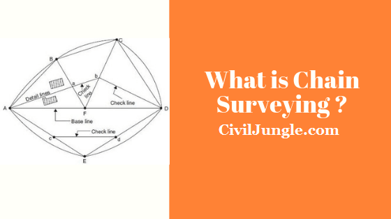
What is Chain Surveying?
Chain surveying is the branch of surveying in which only linear measurements are made in the field. This is suitable for the survey of small areas with simple details and an area that is fairly flat.
It derives its name from the fact that the principle equipment commonly used is the chain. Chain surveying is that type of surveying in which only linear measurements made in the field.
Surveying is suitable for surveys of the small extent on open ground to secure data for an exact description of the boundaries of a piece of land or to take simple details.
The principle of chain survey or Chain Triangulation, as is sometimes called, is to provide a skeleton or framework consists of a number of connected triangles, as the triangle is the only simple draw that can be plotted from the lengths of its sides measured in the field book.
To good results in plotting, the framework should be consist of triangles which are as nearly equilateral as possible.
Chain Surveying
Chain surveying is the branch of surveying in which only linear measurements are made in the field.
This is suitable for the survey of small areas with simple details and an area that is fairly flat. It derives its name from the fact that the principle equipment commonly used is the chain.
Also, read: What Is Bulkage of Sand (Fine Aggregate)
Principle of Chain Surveying
The principle of chain surveying is triangulation. This means that the area to survey is spilled into a number of small triangles which should be well-conditioned.
In chain surveying, the side of the triangles are measured directly from the field by chain or tape, and no angular measurements are used. Here, the check lines and tie lines control the accuracy of the given work.
It is noted that plotting triangles requires no angular measurements to be made if the three sides are known.
Chain Surveying Used in This Situation
- More or less level of the ground surface.
- A small area is to be surveyed.
- A small-scale map is to be prepared.
- The formation of well-conditioned triangles is easy.
Chain Surveying Is Unsuitable When
- The area is crowded with many details.
- The area consists of too many undulations.
- The area is very large.
- The formation of well-conditioned triangles becomes difficult because of obstacles.
Also, read: Consistency Test of Cement
Procedure of Chain Surveying:
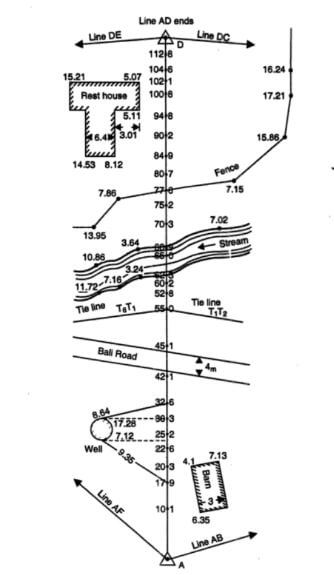
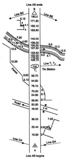
- Baseline, Tie line, Check line, Main survey stations, Tie Stations, Location sketches of survey station
- Two men are required to measure the distance between two places A and B by a chain.
- One man who grabs the ends of the chain and pulls it forward is called the forerunner and the other, the one that is called the back end of the chain.
- The precursor is given a drawing bar and 10 arrows when measuring by a chain.
- A knob in the groove inside the handle of the succeeding chain holds the handle of the chain exactly as it is mounted, pressing it down the heel of the foot, and pulling the chain from the forearm to the perpendicular line to the line AB.
- Then, with the instructions to the succeeding precursor, the trajectory moves line AB to the left or right, until the straight line connecting the points A and B is reached.
- When the drawing is done correctly, the forearm points to the ground where the forearm is fine, with two lines cutting off each other, with the help of a forward shaft or if the ground is hard.
- Then the handle of the forearm chain instantly grabs the chain with both hands and pulls it exactly above the mark on the ground.
- Now the precursor takes one of the ten arrows held by it and knocks it in the semicircular groove provided at the outside of the handle of the chain.
- These arrows indicate the end of a chain. Now the forward chain is pulled forward
- And when the next arrow is dropped, it stops the pioneer from moving forward. Then he will be there for himself
- And when the next arrow is dropped, it stops the pioneer from moving forward. Then he will be there for himself
- The arrow drawn in the groove of the handle of the chain holds the handle in a manner that fits exactly between the two-legged and draws the forearm to the line AB by drawing as described above.
- Then pull the leading chain straight and end at it. Moves the arrow as described above.
- He then pulls the chain forward and lifts the lost arrow in the ground before the successor moves behind it.
- In this way, the process of quantification is repeated until it reaches position B.
- The precursor is usually given 10 arrows at the beginning. Since the precursor picks up the lost arrow successor, the number of arrows should be ten at any given time.
- By doing so, it is not possible to forget the length of the entire chain by measuring the distance.
- The number of chain-lengths measured by the arrow that comes to the successor is calculated.
- When all 10 arrows are moved to the successor, they note the field and give it to the forearm, thus measuring the distance.
- Finally, when the portion of line AB whose length is less than one entire chain remains to be measured, it is precisely drawn to measure the leading chain B reads the distance in front of the link and reports the successor in the field.
- Subsequent drawings have to be made when measuring distances, and the measured distances have to be noted in the field book.
- Thus his responsibility is more than the foregoing.
- Therefore, experienced and intelligent surveyors should be entrusted with the task of succession. Procedure Chain Surveying
Also, read: Soundness of Cement Test
Obstacles in Chain Surveying:
Ranging obstructed
Chaining obstructed
- Possible to chain around the obstructed
- Impossible to a chain around the obstacle
Obstructed in Chaining & Ranging
Also, read: Core Cutter Method
Technical terms of Chain Surveying:
- Base line
- Tie Line
- Check Line
- Main survey stations
- Tie Station
- Offset
- Method of Taking Offsets
- Oblique Offsets
- Range tie and Check tie
- Location Sketches of a survey station
#1. Base Line-
Chain survey graphs. The three lines of a triangle that depend on one line are called the base lines.
The accuracy of the chain survey, based on the accuracy of the baseline. Is dependent
For this, the long line between the survey structure and the line between the region is taken as the base line. Based on the line and even flat ground, the measurement is chosen in a way that is less difficult.
Base, the line should be measured at least twice in the opposite direction. On the map, the survey lines are displayed along the dotted lines and in the middle of the breaks.
#2. Tie Line–
Vertical when the main survey lines pass away in detail the length of the. To minimize this length, a secondary line (T1, T2) that is closest to the details is selected, as shown in the drawing
By doing so, it would be shorter to take the details vertically, be more precise. And time is saved.
This secondary line is called the coincidence line. The accuracy of the survey triangles is also tested as these coincidence lines connect the two points above the main survey lines.
#3. Check Line-
If you know the length of the sides of a triangle, then a triangle can be drawn, but it is not possible to measure the length of the sides of the error drawn.
For this, a lock line is kept in each triangle.
The bottom line is the line connecting the main survey location and any known location above it.
An error is made when comparing the measured length of this line with the drawn length on its map.
In this way, the measurements were taken over the field, and the accuracy of their plotting is tested.
#4. Main Survey Stations-
The vertices of the survey triangles are called the main survey locations. The following are some things to keep in mind when choosing this survey location
- A well-formed triangle should be drawn along the line connecting the survey location.
- The main survey line should be as low as possible.
- Surface and the open area should pass through till baseline is formed.
- The main survey line should pass through the details and until they are made parallel so that the vertical is shortened.
- Each triangle must have a lock line.
- There should be as little difficulty as possible in placing and drawing the length of the survey line.
- All survey lines should pass through the flat ground.
- On high-traffic roads, the survey line should pass over one side of the road so as not to cause frequent interruptions in the measurement, as well as not to disturb the vehicles.
Major survey locations are usually 6 mm on the map. The diameter is shown from the circle and the name of the survey space in the circle, for example, A, is typed.
#5. Tie Station-
The coincidence line is called the coincidence location of the survey locations on both ends. This coincidence is located on the main lines.
Coincidence locations are 6 mm above the map. The long-sided equilateral triangles are shown.
#6. Offset-
Lateral measurements are taken from the survey line to the left and right of the survey line to determine the location (Offset in surveying).
These lateral dimensions are called offsets. There are two types of offset
- Vertical offset
- Oblique offset
#7. Range Tie and Check Tie-
When the details of a building, a building, a fence, etc. are located at the most oblique angle of the survey line, their positioning, as shown in Drawing, is done by coincidence.
The building is located diagonally to the PQRS survey line AB. The line that connects the QP side of the house extends to the survey line. This point is the base of the t-traction combination, and Pt is the basis of the traction combination.
Similarly, p is the basis of the Pp traction coincidence found in extending SP.
QR is also a trace coincidence
#8. Location Sketches of Stations-
The survey of the vast region cannot be completed in a day. So there is the danger of leaving the survey site open.
So we have to reschedule the survey location at any time. A graph of each survey location is created to be taken.
After selecting the survey location, the location is fixed with an incorrect location. The survey site is displayed with oily colors or white on the asphalt or cement road.
Also, read: Part Require for CNC New Machine
Recording the measurements in the Field Book (Field Measurement Book)
The book in which the chain or tape measurements are entered is called the field book. It is an oblong book of size about 20 cm x 12 cm and opens lengthwise.
The main requirements of the field book are that it should contain good quality stout opaque paper. it should be well-bound and of a size convenient for the pocket.
The chain line may be represented either by a single line or by two lines spaced about 1 to 2 cm apart. ruled down the middle of each page.
The double line field book as per below drawing no-1 is most commonly used for ordinary work, the distance along the chain being entered between the two lines of the page.
Single Line Filed Book No 1
Single line field book as per above drawing no-1 is used for a comparatively large scale and most detailed dimension work.
A chain line is started from the bottom of the page and works upwards.
All distances along the chain line are entered in the space between the two ruled lines while the offsets are entered either to the left or to the right of the chain line, as the case may be.
Offsets are entered in the order they appear at the chain line. As the various details within offsetting distances are reached, they are sketched and entered as shown in as per the above single line filed drawing no-1 and as per below drawing no-2 Every chain line must be stained from a fresh page. All the pages must be machine numbered.
Double Line Filed Book Drawing No 2
Chain Survey
Chain surveying is the branch of surveying in which only linear measurements are made in the field. This is suitable for the survey of small areas with simple details and an area that is fairly flat. It derives its name from the fact that the principle equipment commonly used is the chain. Discover the world’s research.
Principles of Chain Surveying-
The principle of chain surveying is to divide the area to be surveyed into a network of connected triangles as a triangle is the only simple figure that can be plotted from the lengths of its sides measured in the field. The field measurements must be so arranged that the area can be plotted by laying down triangles.
Surveying of Buildings Sites with Chain-
Chain surveying is the type of surveying in which only linear measurements are made in the field. The main principle of chain surveying or chain triangulation is to provide a framework consist of a number of well-conditioned triangles or nearly equilateral triangles. It is used to find the area of the field.
Chain Surveying Uses the Principle Of
Chain surveying uses the principle of measurement as triangulation. This implies that the region to be examined is allocated into numerous small triangles, which should be adequately serviced.
Measurement of Distance on Ground with the Help of Chain Is Called as
Gunter’s chain (also known as Gunter’s measurement) is a distance measuring device used for surveying. It was designed and introduced in 1620 by English clergyman and mathematician Edmund Gunter (1581–1626). It enabled plots of land to be accurately surveyed and plotted, for legal and commercial purposes.
Chaining in Surveying
Chain surveying is considered to be the simplest method of surveying in which measurements are taken in the field and other supplementary works like plotting calculations are carried out in office. The measurements in chain surveying are linear- angular measurements are not considered.
Arrow in Surveying
Arrows in surveying are the marking pins that are mostly used in chain surveying. They are used to mark the end of the chain length; if the length of the line to be measured is more than a chain length.
In Chain Surveying the Measurements Made Are
In the chain survey, only measurements are taken in the field, and the rest work, such as plotting calculation, etc. are done in the office. Here only linear measurements are made i.e. no angular measurements are made. This is most suitably adapted to small plane areas with very few details.
Chain in Surveying
The chain is a unit of length equal to 66 feet (22 yards), used in both the US customary and Imperial unit systems. It is subdivided into 100 links or 4 rods. There are 10 chains in a furlong, and 80 chains in one statute mile. In metric terms, it is 20.1168 m long.
Metric Chain in Surveying
The chain is a unit of length equal to 66 feet (22 yards), used in both the US customary and Imperial unit systems. It is subdivided into 100 links or 4 rods. There are 10 chains in a furlong, and 80 chains in one statute mile. In metric terms, it is 20.1168 m long.
Like this post? Share it with your friends!
Suggested Read –
- Types of Sewage Systems
- The Diameter for the Main Water Supply Pipe for a House Is Usually
- Introduction of Gantry Girder | Load on Gantry Gutter | Types of Load on Gantry Gutter
- What Is Dry Pack Mortar | Advantages of Dry Pack Mortar | Disadvantages of Dry Pack Mortar
- What Is Unit Weight | What Is Density | What Is Unit Weight Material | Unit Weight Building Materials
- What Is Pier Foundation | Types of Drilled Piers | Advantages and Disadvantages of Drilled Pier Foundations
- What Is Diversion of Headworks (Rivers) | Types of Diversion Headworks | Component Parts of Diversion Headworks (Rivers)

Plase explain the field procedure in ranging a longer distance (about 140 m) along a flat ground to measure the distance between the two points in chain surveying
pegs in surveying
Peg in surveying is also known as survey peg or survey stakes or survey marking stakes. Survey pegs are used for marking the points and boundaries of the residential or industrial site. Due to pointed ends of the peg, it can be easily installed on the ground. Wooden pegs are cheap and commonly used peg in surveying.
arrows in surveying
Arrows in surveying are the marking pins that are mostly used in the chain surveying.
After the end of each chain length, the arrow is inserted in the ground, but if the ground is hard and difficult, a scratch may be made with the pointed end of the arrow.
cill level
Definition of cill level and lintel level.
The bottom or base of the window i.e the height from the room floor where the window starts is known as cill level.
A window cill may be equal to or greater than the width of the brickwork below it.
The base portion of the cill level is the build of concrete or bricks masonry.
This is very informative and interesting for those who are interested in blogging field.
Thanks
Great! I got my answer. Thanks for sharing.
Thanks
What are the obstacles that occur during chain surveying?and possible solution to overcome those obstacles
What are the process of chaining?
Really this site is a jungle about knowledge…best hai guru 0 to 100 surveying sab Bata diya ek article me..
This is very informative though I’ve never done chain, compass and traverse survey in practical form before, I think I have and idea on how to go about chain survey. However, if there’s a way you can put me through and demonstrate in video format how I will be very grateful.
What are rh advantages and disadvantages of chain survey?