
What Is Surveying? From ancient times, land surveys were conducted to determine the extent of land and to determine the area of land and to determine the area. Engineering projects such as dams, canals, roads, railways, water … [Read more...]
Hand Level Surveying | What Is Site Level | How to Use a Hand Level | Estimating Distance with a Sight Level

Hand Level Surveying Hand level is the device that is generally used by grading contractors and land surveyors. Hand level is worked by comparing multiple points against a reference point to found a height or horizontal … [Read more...]
How to Calculate Staircase Qty | Concrete & Bar Bending Schedule (BBS) for Staircase | Staircase Reinforcement Details
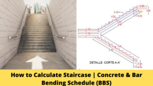
Calculation of Staircase two Different Parts as Below Concrete Calculation for Staircase Bar Bending Schedule for Staircase First, start the calculation of staircase sum basic knowledge of staircase Parts of Stairs … [Read more...]
All About Construction Contract

What Is Construction Contract? Contract, especially when we talk about types of contract in construction and types of contracts in civil engineering, as per the Indian Contract Act 1872 means’agreements that are enforceable as … [Read more...]
All About EDM in Surveying

What is EDM in Surveying? This EDM surveying deals with the principle of EDM in surveying and procedures of separate EDM instruments in surveying that are mountable with optic/electronic theodolites. The EDM full form in … [Read more...]
What Is GIS In Surveying | Definitions of GIS | Parts & Work Flow of GIS | Advantages of GIS

What Is GIS In Surveying? GIS, or gis full form in surveying as 'geographic information system', is a computer program that manages data. Specifically, a gis survey is a type of information system that deals with geographic or … [Read more...]
Basic Plumbing System | Drainage System | Supply and Drainage Subsystems

Basic Plumbing System Plumbing follows the basic laws of nature - gravity-pressure, water seeking its own level. Knowing this, you can understand its "mysteries" and make dozens of corrections to your home's plumbing system. … [Read more...]
What Is Traversing in Surveying | Type of Traversing Surveying | Method of Traversing Surveying | Definition of Traversing Surveying
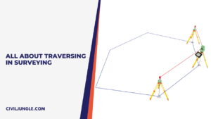
What is Traversing Surveying? (Traverse Definition) The word traverse means 'passing across.' In surveying, it means 'determining the lengths and directions of consecutive lines.' The linear measurements are made with tape … [Read more...]
Principle of Plane Table Surveying Methods | Equipment | Error | Advantage | Limitation

Principle of Plane Table Survey The law of plane tabling is parallelism, meaning the rays drawn from stations to items on the paper are parallel to the lines in the stations to the objects on the ground. The relative … [Read more...]
What Is Linear Measurement Surveying | Types of Linear Measurement Surveying

Introduction of Measuring Distance Distance measurement is usually regarded as the most fundamental of surveying observations. In traditional ground surveys, although many angles might be read, the length of at least one line … [Read more...]
Benchmark in Surveying | TBM in Surveying | GTS Benchmark| Permanent Benchmark | Arbitrary Benchmark
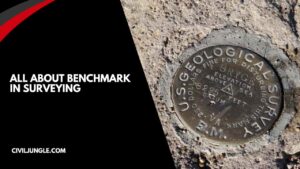
What is a Benchmark in Surveying? Benchmark is a permanent and temporary reference point in surveying. The term is usually applied to any item used to mark a point as an elevation reference. Type of Benchmark in … [Read more...]
House Construction Cost Calculator Excel Sheet
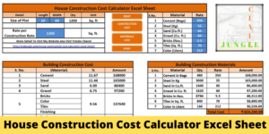
When we think about constructing a new house, probably one question will hit our minds that what would be the cost of construction. This common question arises in our minds when we decide to build a new home. To know the … [Read more...]
What Are the Curves | Types of Curves in Surveying | What Are Horizontal Curves | Types of Horizontal Curves | What Are Vertical Curves | Types of Vertical Curves | Application of Curves
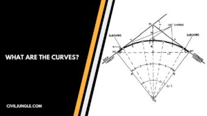
What Are the Curves? The gradual change of direction of regular bends is called curves. When the curves are provided in the horizontal plane, then it’s called a horizontal curve. When the curves are provided with some vertical … [Read more...]
What Is Levelling in Surveying | Types of Levelling in Surveying | Advantages & Disadvantages of Levelling in Surveying
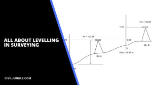
Introduction to Levelling Levelling is one of the most important parts of surveying before starting the construction of roads, dams, or any other structures. It is a branch of surveying which deals with the measurement of the … [Read more...]
What Is Azimuths Surveying | What Is Bearings Surveying | Difference Between Azimuths and Bearings in Surveying
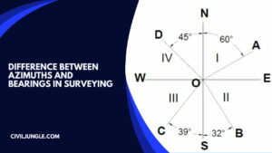
What Is Azimuths Surveying? Azimuths are defined as horizontal angles that are measured from the reference meridian in the clockwise direction. Azimuths are also called whole circle bearing systems (W.C.B). Azimuths are used … [Read more...]
What Is Contour Interval | Calculation of Contour Intervals | Uses of Contour Intervals in Surveying

What Is Contour Interval? A contour interval is a vertical distance or difference in elevation between contour lines. Index contours are bold or thicker lines that appear at every fifth contour line. or A contour interval in … [Read more...]
What Is Leveling | 5 Different Types of Leveling Methods
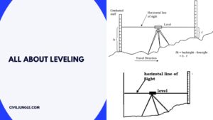
What Is Leveling? Leveling is the most widely used method for obtaining this elevation of ground points relative as a reference datum & is usually carried out as a separate procedure from that used for fixing a planimetric … [Read more...]
Building Layout | How to Building Layout | What Is Method of Layout of Building | Control Lines of Construction | Construction Layout

Building Layout After finalising the building plan and design of the structural component, including foundations, the construction activity can be started. After that, the first step in construction activity is site … [Read more...]
How to Calculate Slab Steel Quantity from Drawing | BBS of Slab
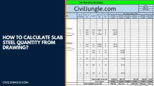
General Guidelines to be Followed In Preparing BBS: The bars should be grouped together for each structural unit, e.g., beam, etc. In a building structure, the bars should be listed floor by floor For cutting and bending … [Read more...]
Prismatic Compass Survey Vs Surveyor Compass. | Least Count of Prismatic Compass & Surveyor Compass
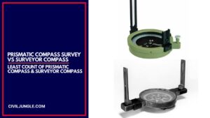
Prismatic Compass Survey is part of the Compass survey. A compass survey is a branch of a survey. This position of an object is located using angular measurements determined by a compass and linear measurements using a chain or … [Read more...]
Total Station in Surveying | Operations of Surveying | Advantage & Disadvantage of Surveying | Types of Surveying | Uses of Surveying

What Is a Total Station in Surveying? The most frequently used surveying instrument today is the total station (As per below figure No1). An entire station is a combination of a digital theodolite, an electronic distance … [Read more...]
What Is Survey Levelling | Important Terms Related to Levelling | What Are Different Types of Levelling | Types of Trigonometric levelling
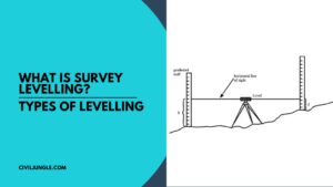
Introduction of Survey Levelling Survey leveling is the method by which we measure the elevation of one land with respect to others. It can also be defined as a method to find out the difference of elevations of different points … [Read more...]
What Is Measurement Book | How to Write Measurement Book | Recording Measurement Book
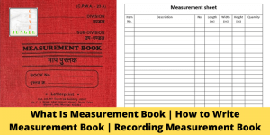
What Is Measurement Book? "Measurement Book" is an important Record Where measurements are recorded for the work done by the contractor, or for the materials received in the site or services rendered MB belongs to the Division … [Read more...]
All About Prismatic Compass Surveying

What Is Prismatic Compass Surveying? What is prismatic compass surveying? It is the kind of prismatic compass survey used only to determine the angles identified as bearing as well as the range is determined by the measuring … [Read more...]
Difference Between Whole Circle Bearing and Quadrantal Bearing | What Is WCB | What Is QB
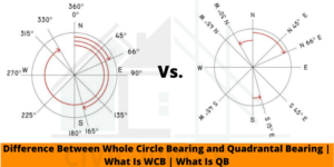
Introduction of WCB Vs. QB When discussing wcb in surveying, it's essential to understand that Whole circle bearing(WCB) and Quadrantal bearing(QB) are the two types of bearing used in the field of surveying for the purpose of … [Read more...]
What Is Transit Theodolite | 24 Different Types of Theodolite Parts
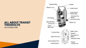
Introduction of Transit Thelotie. Distance between two points (in a small area) is measured in chain survey. Horizontal angles between stations and objects are obtained in a compass survey with an accuracy of half a degree. Points … [Read more...]
Difference Between Plane Surveying and Geodetic Surveying |What Is Geodetic Surveying | What Is Plane Surveying
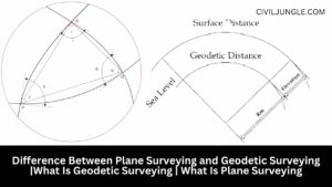
What Is Geodetic Surveying? The geodetic surveying is that type of surveying which takes into account the curvature of the earth's surface for achieving high precision using principles of geodesy. It generally … [Read more...]
History of Remote Sensing | Application of Remote Sensing

History of Remote Sensing In the past time, the only way to store records was photography. The contemporary era of remote sensing, rise with the expansion of flight development. In 1858, the prominent name Nadar clicked … [Read more...]
Instrumental Errors in Leveling | Type of Errors in Leveling
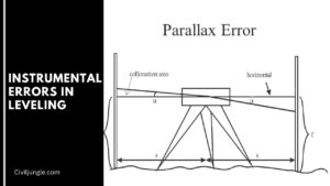
Errors In Leveling As explained earlier, in levelling, it is possible to make blunders, systematic errors, and accidental errors. Proper note keeping and systematic Fieldwork will eliminate the first two, while multiple … [Read more...]
How to Excavation Calculation in Excel Sheet | What Is Excavation | Important Point of Excavation as per IS Code

What Is Excavation? Excavation will be understood as the process of excavating and removing volumes of earth or other materials for the conformation of spaces where foundations, water tanks, concrete, masonry, and sections … [Read more...]
What Is Passometer & Pedometer | Advantage of Passometer & Pedometer | Passometer Vs Pedometer

What Is Passometer? Passometer is an electromechanical and portable instrument, which count the number of paces or velocity of the body movement. It automatically records the number of paces. Its mechanism is being operated by … [Read more...]
What Is Building Bye-Laws | How Essential Building By Laws:

According to the definition, building bye-laws are the norms set forth by the government authorities such as Gandhinagar Urban Development Authority(GUDA), City Corporation and Developing Authorities, for instance, Bangalore … [Read more...]
How to Structural Design a Building/House Step by Step Part-4 (Column Design)
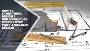
As per our last article How to Structural Design a Building/House Step by Step Part-1, 2 & 3. In this article, we design slab load, slab depth, slab steel design, Slab beam design. Now in this article, we calculated a column … [Read more...]
How to Find House Construction Cost
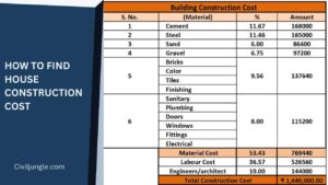
How to Find House Construction Cost Any house construction work started before need some basic detail like before staring work completion. How much cost requirement in house construction. Here, Before construction, we calculate … [Read more...]
Difference Between Carpet Area and Built-up Area
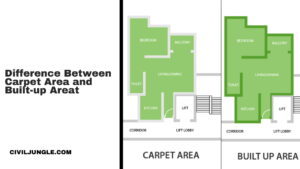
What Is Carpet Area? Carpet area means it is an accurate area that can freely be covered by a carpeted inner a house and is the area of the house, excluding the thickness of the inner walls. If you had to lay out … [Read more...]